The most powerful geospatial
intelligence platform
Automated. Efficient. Intelligent.
Automated. Efficient. Intelligent.

Centralize
Centralize
With GIX Centralize, geoscientists, governments, and resource companies seamlessly transform decades of fragmented archives into a secure and accessible geospatial data repository.
With GIX Centralize, geoscientists, governments, and resource companies seamlessly transform decades of fragmented archives into a secure and accessible geospatial data repository.
Our fully automated AI processing workflow extracts and classifies figures, recognizes geoentities, infuses context, and precisely geotags every data piece, saving months of manual work and accelerating projects. As new data is acquired, it is instantly integrated to the platform.
Our fully automated AI processing workflow extracts and classifies figures, recognizes geoentities, infuses context, and precisely geotags every data piece, saving months of manual work and accelerating projects. As new data is acquired, it is instantly integrated to the platform.
Thousands of hours, regained.
Thousands of hours, regained.
Thousands of hours, regained.

Unstructured and Structured Data
Unstructured and Structured Data
200+
File formats
File formats
70+
Figure types
Figure types
14+
Languages
Languages
Reports
Reports
Maps
Maps
Figures
Figures
Tables
Tables
Logs
Logs
Pictures
Pictures

Jon Coates
Former Chief Geoscientist, BHP, & Advisory Board Member
"What GeoIntelX has developed resolves a strategic flaw in the backbone of most major resource organizations’ development plans: the ability to integrate and use the wealth of knowledge they have and keep expanding. This is a game-changer."
"What GeoIntelX has developed resolves a strategic flaw in the backbone of most major resource organizations’ development plans: the ability to integrate and use the wealth of knowledge they have and keep expanding. This is a game-changer."
“What GeoIntelX has developed resolves a strategic flaw in the backbone of most major resource organizations’ development plans: the ability to integrate and use the wealth of knowledge they have and keep expanding. This is a game-changer.”


Innovation Breakthrough
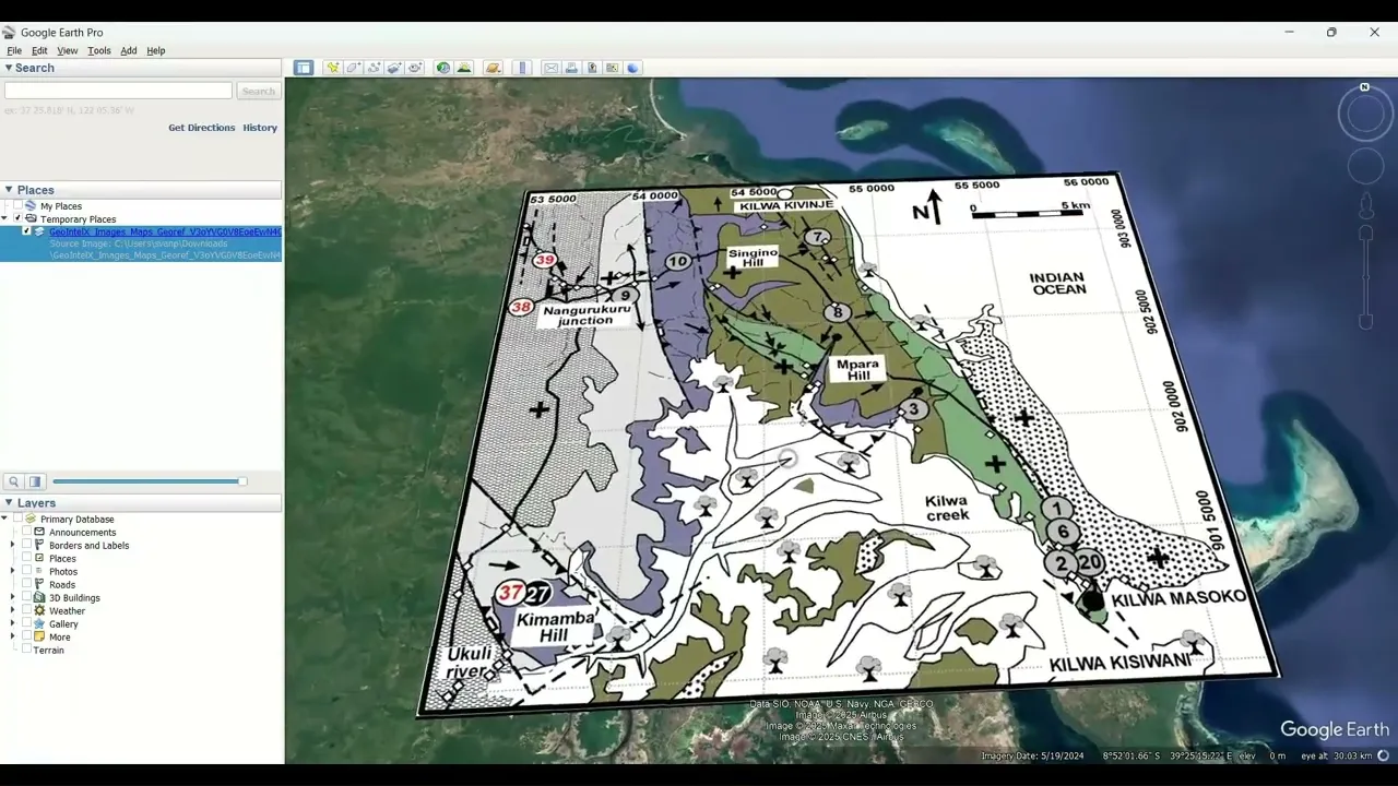
Automated Georeferencing
Automated Georeferencing
Save hours with automated georeferencing and
export of any map, no coordinates required
Innovation Breakthrough
Automated Georeferencing
Save hours with automated georeferencing and
export of any map, no coordinates required
Innovation Breakthrough
Automated Georeferencing
Save hours with automated georeferencing and
export of any map, no coordinates required
Innovation Breakthrough
Automated Georeferencing
Save hours with automated georeferencing and export of any map, no coordinates required
"One of our greatest breakthroughs is our geolocation engine - it can spatially locate documents by analyzing the place names and geological terms mentioned in the text, even if maps or coordinates are not present. It also automatically geo-references maps, making unstructured content searchable on the interactive globe."
"One of our greatest breakthroughs is our geolocation engine - it can spatially locate documents by analyzing the place names and geological terms mentioned in the text, even if maps or coordinates are not present. It also automatically geo-references maps, making unstructured content searchable on the interactive globe."

Stijn van Puijvelde
Director of Engineering & Data Science, GeoIntelX
Director of Engineering
and Data Science, GeoIntelX


Ready to centralize your data?
Ready to centralize your data?
Ready to centralize
your data?
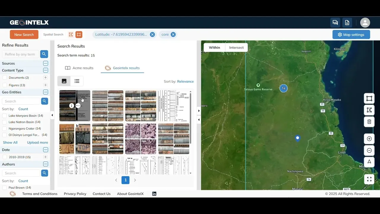
Analyze
Analyze
Expedite data exploration and interpretation with cutting-edge tools on our intuitive geospatial exploration platform.
Expedite data exploration and interpretation with cutting-edge tools on our intuitive geospatial exploration platform.
2x Faster Analysis
2x Faster Analysis
Augment with public data, like land ownership, tenements, and utilities
Augment with public data, like land ownership, tenements, and utilities
Get answers using powerful search and filters
Get answers using powerful
search and filters
Export geo-referenced data and continue analytical workflows
Export geo-referenced data and continue analytical workflows
GeoTIFF
GeoTIFF
GoogleEarth
GoogleEarth
GIS
GIS
Geophysical Tools
Geophysical Tools
Predict
Predict
Make informed decisions with visualized AI predictions that account for all available data and identify unseen risks for your project.
Make informed decisions with visualized AI predictions that account for all available data and identify unseen risks for your project.
Perfect for regional exploration, site identification, brownfields expansion, and more.
Perfect for regional exploration,
site identification, brownfields expansion, and more.

Ore Grade & Tonnage
Ore Grade & Tonnage
Reservoir Quality & Presence
Reservoir Quality & Presence
CCUS Suitability (e.g., Porosity, Seal Integrity)
CCUS Suitability (e.g., Porosity, Seal Integrity)
Geotechnical Risk (e.g., Slope Stability, Subsidence)
Geotechnical Risk (e.g., Slope Stability, Subsidence)
Mineral Exploration Targets
Mineral Exploration Targets
Hydrocarbon Prospectivity
Hydrocarbon Prospectivity
Groundwater Resource Potential & Risk
Groundwater Resource Potential & Risk
Geothermal Resource Assessment
Geothermal Resource Assessment
Millions saved avoiding futile campaigns
Millions saved avoiding futile campaigns

Go even faster
with our AI Agent
Conduct complex analysis and brainstorm theories with our geo-trained
AI Agent that distills insights, cites sources, and explains reasoning.
Go even faster
with our AI Agent
Conduct complex analysis and brainstorm theories with our geo-trained AI Agent that distills insights, cites sources, and explains reasoning.
Go even faster
with our AI Agent
Conduct complex analysis and brainstorm theories with our geo-trained AI Agent that distills insights, cites sources, and explains reasoning.
Go even faster with our AI Agent
Conduct complex analysis and brainstorm theories with our geo-trained AI Agent that distills insights, cites sources, and explains reasoning.
"The GIX prediction tools were instrumental in confirming our geological assumptions for our lithium project in the Ivory Coast. The logic was traceable and we’re already seeing indications that the AI was right."
"The GIX prediction tools were instrumental in confirming our geological assumptions for our lithium project in the Ivory Coast. The logic was traceable and we’re already seeing indications that the AI was right."

Y.C.
CEO, Firering Strategic Minerals and Limeco


Explore Smarter
Resurface years of neglected data, avoid costly re-acquisition, and quickly eliminate low-probability targets.
Accelerate Time to Target
Boost Probability of Success
Explore Smarter
Resurface years of neglected data, avoid costly re-acquisition, and quickly eliminate low-probability targets.
Accelerate Time to Target
Boost Probability
of Success
Explore Smarter
Resurface years of neglected data, avoid costly re-acquisition, and quickly eliminate low-probability targets.
Accelerate Time to Target
Automate digitization and geo-referencing - move seamlessly from data gathering to analysis and decision-making.
Boost Probability of Success
Reveal hidden insights across all public and proprietary data, and make smarter decisions with AI-powered targeting.
EARTH UNLOCKED.
Join our newsletter
Solutions
Resources
© GeoIntelX 2025

EARTH UNLOCKED.
Join our newsletter
Solutions
Resources
© GeoIntelX 2025
EARTH UNLOCKED.
Join our newsletter
Solutions
Resources
© GeoIntelX 2025
EARTH UNLOCKED.
Join our newsletter
Solutions
Resources
© GeoIntelX 2025
EARTH UNLOCKED.
Join our newsletter
Solutions
Resources
© GeoIntelX 2025